 Dozens
of royal capitals dot Thailand's map, more than would seem possible
for a country of its size and short history. In truth, most were
little more than large settlements owing allegiance to a distant
king, but their design says much about how the Thais — essentially
a rural culture — regarded cities, kings, and Buddhism. Dozens
of royal capitals dot Thailand's map, more than would seem possible
for a country of its size and short history. In truth, most were
little more than large settlements owing allegiance to a distant
king, but their design says much about how the Thais — essentially
a rural culture — regarded cities, kings, and Buddhism.
For Siamese princes, royal cities were bastions of culture and
religion, built to reflect the glories of the reign, impress their
neighbors, and to defend the realm when those neighbors cast covetous
eyes on the kingdom’s wealth. Despite their wide geographic
distribution, royal cities shared a number of common features
dictated by pragmatism and cosmology.
Their contours were based on ancient Chinese models, as reflected
by their names. “Wiang” (as in “Vientiane”,
the capital of Laos, and “Wiang Kum Kham”, Chiang
Mai’s predecessor) suggests a circular outer wall. “Chiang”
(contained in “Chiang Mai”, “Chiang Rai”
and most northern Thailand royal cities) describes a square or
rectangular wall. All these walled cities were surrounded by moats,
in part to defend their inhabitants but for symbolic purposes
as well. These “hills” and “seas” replicated
Mount Meru, the mythic Himalayan home of Buddhism’s gods,
a holy city — generally identified as Tibet’s Mt.
Kailash — ringed by seven mountain ranges and seven seas.
Although they were primarily administrative centers, nearly
all these royal cities were regarded as sepulchers of religion.
The Royal Chronicles are replete with stories of rusi (religious
hermits) who selected building sites for new royal cities based
on their mystical and cabalistic qualities. Cities were considered
officially established only after appropriate ceremonies to propitiate
the spirits of the land had been performed at a date and time
selected by astrologers.
Monarchs tended to fill their cities with monuments that replicated
those in great Buddhist cities of the past. The List of Kings
compiled by Rama I in 1782 traced the development of Siamese cities
from the death in India of Lord Buddha in the 6th century B.C.,
through the great Indian Emperor Asoka, on through the Angkorian
kings of 11th-13th-century Cambodia, and on to the end of Thailand’s
Ayutthaya period in 1767. Because kings were regarded as the supreme
upholders of the Buddhist faith the cities they created were seen
as repositories of Buddhist lore, and sites for the perpetration
of the faith.
The far northern towns of Chiengsaen and Chiang Rai were among
Thailand’s first royal cities. As their names suggest, these
13th-century cities were rectangular, were girded by high walls,
and were protected by waterways (Chiengsaen on the banks of the
Mekong River; Chiang Rai on the Kok River). Smaller kingdoms —
more fiefdoms than full-fledged cities — at Nan and Phitsanuloke
were similarly-designed.
While these cities held sway over the North for two centuries,
Sukhothai is generally regarded as Siam’s (Thailand’s
name until 1938) first capital. Sited at the head of the Chao
Phya River Valley, it began its life as an outpost of the Khmer
empire centered at Angkor Wat. When Angkorian power waned in the
13th century, the Thai leaders stepped into the vacuum and begin
building monuments that would eventually transform Sukhothai into
one of Asia’s premier kingdoms.
Because it may originally have been a Khmer city, Sukhothai’s
design provides an interesting contrast to most Thai cities. Whereas
the Thai custom was to build on a river that would provide transport,
defense, and irrigation, Khmers built on highlands and channeled
water to it from distant rivers. They may have reasoned that by
being on high ground they would be less susceptible to disease
than were they to occupy a damp area near a river. Sukhothai was
situated midway between the Yom and the Wang rivers. It was connected
to them by two 50-km. canals, a considerable engineering feat
for its day.
A Sukhothai inscription of 1292 notes that the city was surrounded
by three concentric earthen ramparts—the Meru principle—punctuated
by four gates. The walls enclosed a vast city stretching 1,800
meters from west to east, and 1,360 meters from north to south.
Its principal monument was Wat Mahathat a gigantic Buddhist temple
built along Singhalese (Sri Lankan) lines, and situated at the
center of the city to symbolize Mount Meru. The rest of the city
fell away like a valley hemmed by the mountains and seas (walls
and moats) of the world.
Wat Mahathat was regarded as a bi-directional transmitter, its
prang or central tower receiving the blessings of heaven and broadcasting
them over the surrounding populace, and at the same time sending
the prayers of the pious skywards to the omniscient gods.
Only religious buildings were constructed of brick and stone in
the belief that while human life was transitory, the gods were
eternal and thus deserved permanent shrines. Ephemeral mortals
lived in wooden or thatch houses of which no evidence remains
today in Sukhothai. In time, kings would come to regard themselves
as incarnations of deities, and would build palaces of brick and
stucco. The ruins of King Thammaraja’s palace, who died
in 1370, can still be seen.
The only northern royal city still thriving is Chiang Mai, founded
by 1296 by King Mengrai. Legend says that he saw a pack of dogs
chasing a deer which escaped by hiding in a copse ringed by water.
Mengrai took this as a sign to build his own city as a refuge
hemmed by a river.
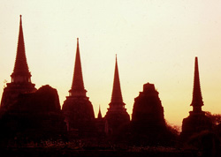
The most striking Siamese royal city is Ayutthaya, in the Central
Plains. Numerous fanciful tales explain its founding but the most
reliable is found in the Dynastic Chronicles compiled by King
Rama I’s (1782-1809) scribes several hundred years after
the events described. They relate that the Prince of U-thong,
his low-lying city wracked by a cholera plague, sought a new site
on higher ground to the east. He found it at the confluence of
the Pasak and Chao Phya Rivers. There, his soldiers dug shunts
to combine their waters and thereby create an island. In 1351,
he dedicated his new city, Ayutthaya, which would serve as Siam’s
capital for the next 416 years.
During the reign of King Ramthibodi (as U-Thong styled himself;
1351-1369), the city walls were made of mud and the buildings,
including the royal palace, were built of wood. Brick walls were
not erected until 1548 during the reign of King Chakrapat, the
first of a series of monarchs to erect magnificent stone and brick
temples and monuments. By the 17th century, Ayutthaya was a thriving
metropolis. In 1636, Joost Schouten, Director of the Dutch East
India Company for Siam, described it as "encompassed with
a thick stone all about six English miles round; the Suburbs are
on the other side of the River, closely building, and full of
Temples and Cloysters, lying in a flat and fruitful Country.
"The Streets of the walled Town are many of them large, straight,
and regular, with channels running through them, although for
the most part of small narrow Lanes, Ditches, and Creeks most
confusedly placed. The Citizens have an incredible number of small
Boats or Prawes which come to their very doors, especially at
floods and high water.
"The building of the Houses is according to the India fashion,
slight and covered with Tiles; but the City is beautified with
more than three hundred fair Temples and Cloysters, all curiously
builded and adorned with many gilded Towers, Pyramids, and Pictures
without number. The King’s Palace is seated upon the River,
resembling a little Town apart, great and magnificent, many of
its Buildings and Towers being entirely gilded."
Modern-day architect Sumet Jumsai has described it more precisely
as having "walls approximately 12 km. long and equipped with
17 watchtowers. The Grand Palace had another seven watchtowers
and the Palace to the Front had three.” There were more
than 90 city gates, about 20 of which had canal locks to allow
passage to boats. The canals within the city proper totaled 56.4
kilometers in length. Dug haphazardly, the original canals meandered
but late in the 17th century, King Narai straightened the “most
confusedly placed” canals along a fairly regular grid.
Residents were quartered according to nationality. Only Thai
royals and high personages and their retainers, merchants and
officials, lived within the city walls. There was a large Chinatown.
Foreigners were confined to settlements outside the city walls
although an Eglise Episcopale or seminary built for French missionaries
was constructed by King Narai in 1676 in the city proper. Ships
were anchored just south of the city.
The city’s great wealth is attested to by European trader,
M. Glanius: "Gold is so common that the cattle is served
in vessels of no other metal. They have an infinite number of
idols, most being of gold or silver, some of copper and pewter,
and very few of stone or wood. There were 4,000 images in the
city, there is not single one but what is either gold or gilt.
The throne of the king is of massive gold, and all beset with
precious stones. There is no court more superb than the Emperor."
Some idea of the design and grandeur of the palace may be gained
from an account written by the Jesuit priest, Pere Guy Tachard,
in 1686: "We entered...into the first court of the palace
where there were on one side fifty war elephants with gold harnesses
and on the other side, two regiments of guards, drawn up in battle
order and numbering eight hundred men. From there we passed into
the second court, where there were eight other war elephants and
a company of sixty Moors on horseback..."
"...in the third court there were sixty elephants with
harnesses far richer than those in the first court, and two armed
regiments of the Garde du Corps numbering two thousand men. On
entering into the fourth court, the pavement was half covered
with mats, and found here were two hundred prostrated soldiers
carrying swords of gold and tambac...In two rooms further room
were five hundred Persians of the
king's guards…
"...The fifth we entered was covered with fine mats on
which prostrated all the mandarins of the third, fourth, and fifth
orders and some distance from there were those of the second order,
in the same position on Persian carpets. Having passed between
all the mandarins and crossed so many courts, we at last arrived
at the foot of a stairway where were found on the right, two elephants
completely covered with gold and, on the left, six Persian horses,
parts of whose saddles were of massive gold and harnesses sprinkled
with pearls, diamond, rubies, and emeralds..."
"...The king wore a tiara brilliant with jewels. It was
a large bonnet terminating in a pyramid around which were three
circles of gold placed at some distance from each other. He had
on his fingers many huge diamonds, sparkling greatly; his jacket
was red with a fringe of gold and over it it had a gauze of gold
which had large diamond buttons; all this, with a lively manner,
filled with ardour and smiling always, gave much grace and majesty."
Despite its vast wealth and seemingly impregnable walls, Ayutthaya
fell to Burmese invaders in 1767, due as much to internal wrangles
and betrayal as to enemy guile. The Burmese burned and pillaged
it, so thoroughly stripping it of its gold and of its population,
that for nearly a century afterwards, it was a city of ghosts
who scavanged among the ruins.
To increase the distance between themselves and the Burmese, the
surviving Thais moved south down the Chao Phya River. At the riverside
town of Thonburi, opposite present-day Bangkok, King Taksin established
his capital. So engrossed was he in wars against numerous invaders
taking advantage of a weakened Thai state, that he constructed
few buildings and Thonburi remained the capital until he was deposed
in 1782.
In its early days, Bangkok had been a village of fishermen and
fruit trees. By the 16th century, it was serving as Ayutthaya's
first line of defense against ships proceeding up the Chao Phya
River. Its shape was determined by King Chakrapat (1534-1546)
of Ayutthaya who cut a channel through a loop of the river between
what is today the mouths of Klong [canal] Bangkok Noi and Klong
Bangkok Yai. Over the years, erosion widened it and it became
the main artery between the sea and Ayutthaya. By the 17th century,
Bangkok-Thonburi was a customs port for ships seeking to trade
in Ayutthaya. In 1687, the French — under instructions from
King Narai — built fortifications along the river and garrisoned
troops there.
In 1782, King Rama I, Taksin’s successor, moved his capital
across the Chao Phya River to the eastern bank. The Dynastic Chronicles
for his reign explain that:
"The king...came to decide that the…land on the east
bank was peninsular with more than half of the area surrounded
by the river. If the capital city were to be established on the
east side, it would be easier to defend..." because the river
would lie between the palace and the Burmese. “The ceremony
of raising the zero milestone of the new capital city [today located
at Lak Muang, off the northeastern corner of Wat Phra Kaew] was
performed on Sunday, the tenth day of the waxing moon of the sixth
month at 6:54 in the morning.”
The site chosen by the surveyors for the new royal residence was
occupied by Chinese merchants who were asked to relocate just
to the south at what ultimately would become Chinatown.
"The king then ordered units set up to tattoo conscriptable
subjects [principally Lao war captives] into labor units...some
to make new bricks, some to dismantle old bricks from the walls
of the old capital in Ayutthaya and bring them down [by boat]..."
By utilizing bricks from Ayutthaya, King Rama I demonstrated pragmatism
and a sense of history, the old bricks imbuing his royal city
with a portion of Ayutthaya’s glory.
"Ten thousand Cambodians were levied to construct a canal
as a moat along the east side of the capital. It extended from
Banglamphu all the way to the river in the south...The king named
it Ropkrung [surround the city] Canal.” Another large canal
was constructed just north of the Sakae Temple. The king named
it Mahanak [Great Serpent] Canal and declared that he wanted it
to be a place “where the people of the capital city could
go boating and singing and reciting poems during the higher-water
season like the custom observed in the former capital at Ayutthaya."
Fearing that the Burmese might return, the low lying ground around
Rajdamnern Avenue was left as a marsh and only temporary bridges
were constructed between the city gates and the mainland. As a
further precaution, drums, each with a distinctive sound and purpose,
were beat to announce the time, fires, invasions, and general
emergencies.
The new city quickly attracted new residents. In 1822, British
emissary John Crawfurd estimated the population to be around 50,000.
By 1900, the populace had grown to 500,000. From the royal palace,
the city stretched south and north along the river. Seeking a
new direction King Chulalongkorn built a summer palace in the
Dusit area to the northeast in 1900, and city began creeping eastward.
Today, sprawling Bangkok looks nothing like the recreation of
regal Ayutthaya as King Rama I envisioned it. But the gilded spires
and glittering temples of the old royal city echo the grand edifices
and monuments of Ayutthaya and its royal predecessors, recalling
an era when they were regarded as earthly paradises fit for kings.
|